12651
12651
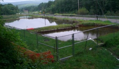
Shamokin Creek Site 15
/index.php/project-shamokin-creek-site-15
Shamokin Creek Site 15
Project Details
|
Original Construction Year
|
2005
|
|
Most Recent Rebuild Year
|
|
|
Total Cost
|
0.00 |
|
Total Capital Cost
|
$0.00
|
|
Latitude / Longitude Method
|
Unknown
|
|
Latitude
|
40.780712
|
|
Longitude
|
-76.515436
|
|
Elevation
|
0
|
|
Project
|
Shamokin Creek Site 15
|
|
Project Type
|
Passive Treatment System
|
|
Project Status
|
Needs Maintenance
|
|
AMD Source
|
Underground
|
|
Stream
|
Shamokin Creek
|
|
Watershed
|
|
|
River Basin
|
Susquehanna
|
|
Quad
|
Shamokin
|
|
City/Township
|
Coal Township
/ Coal
|
|
County
|
Northumberland
|
|
State
|
PA
|
Description: Corbin Water Level Drift (SCARLIFT Site 15) discharges AMD directly to the Shamokin Creek in the Middle Sub-watershed.
Water Quality Data Summary