12725
12725
Possum Hollow 1
/index.php/project-possum-hollow-1
Possum Hollow 1
Project Details
Original Construction Year
2008
Most Recent Rebuild Year
Total Cost
0.00
Total Capital Cost
$0.00
Latitude / Longitude Method
Unknown
Latitude
40.875000
Longitude
-80.375000
Elevation
0
Project
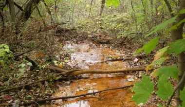
Possum Hollow 1
Project Type
Stream
Project Status
AMD Source
Stream
Possum Hollow 1
Watershed
River Basin
Ohio
Quad
Beaver Falls
City/Township
New Beaver Borough
County
Lawrence
State
PA
Description: Possum Hollow is impacted by acid-mine drainage. This project will monitor the water coming from the mine, as well as upstream and downstream of the discharge.
Water Quality Data Summary
Contact Person: Contact Organization: Project Designer: Project Designer Organization: Project Responsible Organization:
Title
System
D1-337 Datashed 1.0